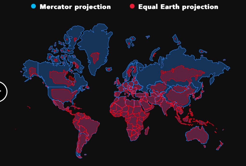
The world’s most familiar map could soon become less familiar. On September 4, the United Nations General Assembly approved the “Correct the Map” resolution, sponsored by Togo on behalf of the group of African countries. There were 164 votes in favor, one against, and six abstentions.
On Friday, the United Nations General Assembly adopted an African proposal for a new world map, which shows countries’ true size relative to one another.
— UN News (@UN_News_Centre) September 4, 2026
In favor: 164
Against: 1
Abstentions: 6 pic.twitter.com/5BE4LUiojH
The text calls on governments, schools, international organizations, and technology companies to use map projections that better represent the actual sizes of the continents whenever comparisons of land area are relevant. Among those mentioned is Equal Earth, developed in 2018.The resolution does not ban the Mercator projection—the most widely used—nor does it specify which map should replace it. Above all, it calls for considering the consequences of different projections and teaching about their limitations.
A map designed for sailors
Gerardus Mercator developed his projection in 1569. The goal was practical: to allow sailors to chart courses with constant directions on maps. For this purpose, the projection proved extremely effective.The problem arises when the same map is used to compare the sizes of territories. The surface area of regions far from the Equator is progressively distorted. Greenland, for example, may appear similar in size to Africa, even though Africa is about fourteen times larger.
The same effect applies to the northern regions of Europe, Asia, and the Americas. The result is a representation in which the lands near the poles occupy much more space than they would on a map of equal area. This distortion has long been known and is a mathematical consequence of the projection. The issue raised by the African group concerns its everyday use: a map designed for navigation has also become an educational and cultural tool through which generations of people have learned to imagine the planet.
Robert Dussey, Togo’s foreign minister, summed up the organizers’ position with a statement that encapsulates the entire initiative: “Maps shape our understanding of the world.”
Paris Changes Its Map
A few hours before the UN vote, French Foreign Minister Jean-Noël Barrot announced that French diplomacy would gradually phase out the Mercator projection in favor of the Eckert IV projection.
The new map depicts continental landmasses in a more proportionate manner. On French diplomatic maps, therefore, France, the United States, and Russia will appear relatively smaller than countries located at equatorial latitudes.France will therefore not adopt Equal Earth—the projection mentioned in the UN resolution—but rather Eckert IV, developed in 1906. Both belong to the family of projections that seek to best preserve the proportions of land areas.
Even a piece of paper has a purpose
The discussion brought to light a fundamental rule of cartography: there is no flat projection capable of preserving area, shape, distance, and direction all at once. Every representation of the Earth involves a choice. The Mercator projection therefore remains useful for certain purposes and will continue to be used. The UN has not decreed its obsolescence. The issue rather concerns the choice of tool in relation to the purpose.
The United States voted against the resolution, calling it a “radical ideological project.” Ukraine and the European Union, on the other hand, raised the issue of the representation of disputed territories. Brussels clarified that the measure concerns the proportions of land areas and does not alter borders, sovereignty, or territorial status.Perhaps the most interesting aspect concerns schools. When teaching geography to students, a map that significantly distorts land areas can convey an inaccurate picture of the relative sizes of the continents. Presenting different projections side by side would also demonstrate this: every map depicts the Earth through a specific technical choice.
The UN vote does not change geography, nor will it make the Mercator projection disappear from textbooks overnight. It can, however, change a convention. And that alone is a rather significant change for a map.